
Korea Meteorological Administration: Sea surface temperature anomaly reached a record 2.6°C in October; peak expected in December
WMO forecasts an anomaly of +3.8°C from November through January, potentially surpassing the strongest El Niño on record since 1950
South Korea is likely to have a milder, wetter November and December; an influx of Arctic air could bring a sudden cold snap
Key points
▶ Using the Relative Oceanic Niño Index (RONI), which the U.S. National Oceanic and Atmospheric Administration (NOAA) adopted as its official measure in February, the sea surface temperature anomaly in the Niño 3.4 region was +2.0°C in August–October. An anomaly of +2.0°C or more marks a very strong El Niño.
▶ In its latest outlook, the World Meteorological Organization (WMO) expects the average anomaly in the Niño 3.4 region to reach +3.8°C from November through January, peaking in December.
▶ That would exceed the previous record of +2.6°C set during the 2015–16 El Niño.
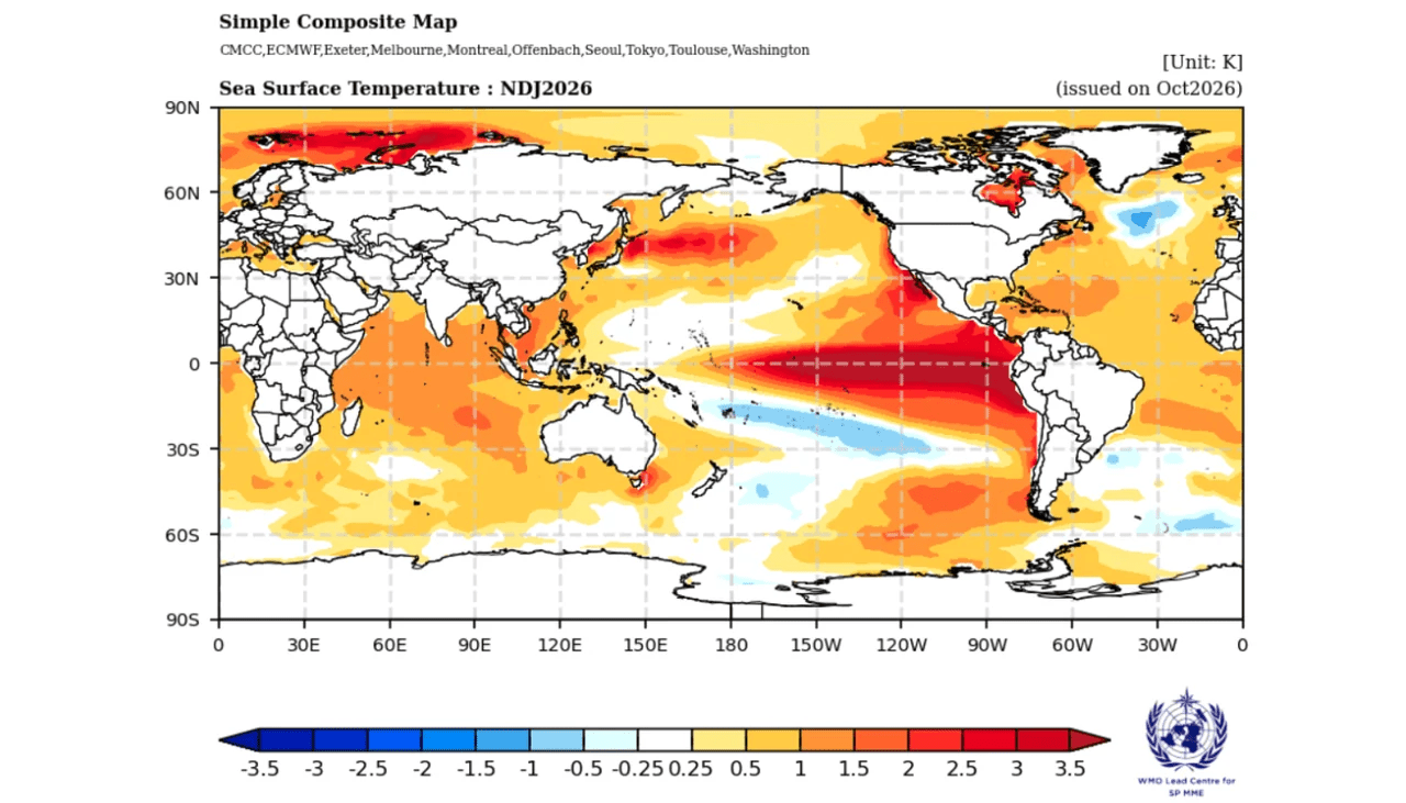
An exceptionally strong El Niño that will affect the global climate this winter is developing to record levels. By NOAA’s measure, the 2026–27 El Niño reached the “very strong” category, with a sea surface temperature anomaly of +2.0°C in the Niño 3.4 region during August–October.
In its latest outlook, the WMO expects the average anomaly to rise to +3.8°C from November through January, peaking in December. This would be higher than that of any El Niño observed since 1950. The Korea Meteorological Administration (KMA) expects the event to peak in December and forecasts a high likelihood that temperatures and precipitation in South Korea will be above average in November and December.
◆ “Very strong” even after the index changed
El Niño strength is measured by how much sea surface temperatures in the central equatorial Pacific’s Niño 3.4 region exceed average levels. An average anomaly over three months of at least +0.5°C indicates a weak El Niño, +1.0°C or more a moderate one, +1.5°C or more a strong one, and +2.0°C or more a very strong one—the category commonly called a “super El Niño.”
NOAA changed its benchmark index in February. The traditional Oceanic Niño Index (ONI) uses the temperature anomaly relative to a long-term average. As global warming has raised temperatures across the tropical oceans, however, anomalies can also become larger when there is no El Niño.
The new index, RONI, removes the broader warming signal across tropical oceans to isolate the El Niño signal. In 2026, the two indices differed by 0.4–0.6°C from one three-month period to another. Even under the stricter RONI measure, the anomaly reached +2.0°C in August–October. Under ONI, it had already reached the very strong category at +2.2°C in July–September, then climbed to +2.5°C in August–October.
◆ WMO’s +3.8°C forecast would break the 2015–16 record
In its latest outlook, the WMO forecasts an average anomaly of +3.8°C in the Niño 3.4 region from November through January. This is the multi-model average of forecasts from 13 agencies, with the highest value expected in December. The figure uses the traditional anomaly measure; converted to RONI, it is estimated at roughly +3.2°C to +3.4°C. That is only an approximation, since the difference between the two indices is not constant. In an October forecast, the WMO also projected an average anomaly of +3.7°C for October–December, saying it would exceed the record of +2.6°C set in November 2015–January 2016.
WMO Secretary-General Saulo said, “El Niño is firmly established and strengthening rapidly,” adding that it “could become one of the strongest El Niño events since 1950.” The WMO puts the probability that El Niño will continue through February at nearly 100%.
August was the hottest on record, and global sea surface temperatures also reached a record high that month. The WMO says years with strong El Niño events are often recorded as the hottest years.
◆ More rain in southern Brazil, drought in the north
El Niño’s effects are expected to vary by region. Brazil is a prominent example. There is more than an 80% chance that precipitation from November through January will be above average in northern Rio Grande do Sul, Santa Catarina and western Paraná.
By contrast, there is more than an 80% chance of below-average precipitation in the north, with the areas that have received the least rain in recent months expected to become even drier. Temperatures are also more than 80% likely to be above average across almost all of Brazil, except Rio Grande do Sul. The contrast of rain in the south and drought in the north is a typical El Niño circulation pattern.
The WMO also expects above-average rainfall in East Africa, parts of Central Asia, the coast of East Asia and southeastern South America, and below-average rainfall in the Indian subcontinent, the western Pacific and southern Central America.
◆ Mild, wet early winter in South Korea, with cold air a factor in January
On the 6th, the KMA officially confirmed that El Niño had begun in May this year and forecast that the current event would become the strongest on record.
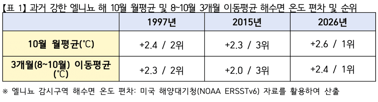
The KMA defines the start of an El Niño as the first month in which the three-month moving average sea surface temperature in its monitoring region is at least 0.5°C above average and remains so for five months or longer. The October anomaly was +2.6°C, while the August–October moving average was +2.4°C. Both were the highest for the same period since records began in 1950.
Those figures exceeded the anomalies recorded in October of previous strong El Niño years: +2.4°C in 1997, the second-highest, and +2.3°C in 2015, the third-highest. The KMA expects the event to peak in December and develop into the strongest El Niño on record, with sea surface temperatures remaining high afterward.
The KMA forecasts that January temperatures will generally be above average and precipitation near average, but says temperatures could fluctuate considerably due to temporary incursions of cold air.
KMA Administrator Lee Myun-sun said, “The strong El Niño’s influence this winter is expected to bring temperatures above average and generally more precipitation.” She added, “Because multiple climate factors interact, people should also prepare for abrupt weather changes, including cold waves.”
She continued, “We will closely analyze the development of El Niño and the climate factors affecting the Korean Peninsula, and provide climate forecasts so that the public and relevant agencies can prepare in advance.”