
Key points
▶ The World Meteorological Organization (WMO) said on the 8th (local time) that El Niño is expected to peak in December and could develop into one of the strongest events since 1950. There is a near-100% chance it will continue through February next year.
▶ The sea-surface temperature anomaly in the central and eastern equatorial Pacific rose from 1.6°C in June to 2.5°C in August. The WMO forecasts an average anomaly of about 3.7°C from October to December. If that forecast materializes, it would exceed the 2.6°C record set in 2015–2016.
▶ A strong El Niño can raise temperatures and alter rainfall patterns around the world, increasing the risk of droughts and floods. Korea’s weather agency also expects a strong El Niño to persist from October through December this year.

El Niño, which influences the global climate, could develop into one of the strongest events ever observed, according to a new forecast. With sea-surface temperatures in the equatorial Pacific rising rapidly, concerns are growing about increased risks of heat waves, droughts and floods around the world.
In its “Global Seasonal Climate Update,” released on the 8th (local time), the World Meteorological Organization (WMO) forecast that El Niño will continue to strengthen until it peaks in December. If current trends continue, it could rank among the strongest El Niño events since 1950.
El Niño is a natural phenomenon in which sea-surface temperatures in the central and eastern equatorial Pacific rise above average. It typically occurs every two to seven years and lasts for about nine to 12 months. Changes in ocean temperatures also alter atmospheric circulation and rainfall patterns, affecting regions around the world.
Sea-surface temperature anomaly forecast: 3.7°C
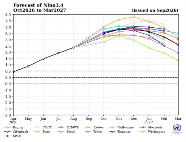
According to the WMO, the Niño 3.4 index, which measures El Niño’s strength, rose from 1.6°C above average in June to 2.5°C in August.
The Niño 3.4 index indicates how much warmer than average the sea-surface temperatures are in a specific area of the central and eastern equatorial Pacific. Larger temperature anomalies tend to indicate a stronger El Niño.
The WMO forecasts that the average sea-surface temperature anomaly from October to December this year will reach about 3.7°C. That would be 1.1°C higher than the previous record of 2.6°C, set from November 2015 to January 2016. If the forecast proves accurate, it would set a new record for the strongest El Niño observed.
Thirteen major meteorological agencies around the world contributed to the forecast, combining analyses of ocean observations and climate prediction models.
WMO Secretary-General Celeste Saulo said El Niño is already firmly established and strengthening rapidly. She added that the probability it will persist through February next year is close to 100%.
However, 3.7°C is a forecast from climate prediction models, not an observed figure. The event’s actual strength will depend on how sea-surface temperatures change in the coming months.
Release of heat stored in the ocean
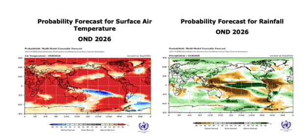
The concern about a strong El Niño stems from the fact that the oceans are already warm.
El Niño does not create new heat. Heat stored in the Pacific is exchanged with the atmosphere, affecting global temperatures. The concern is that ocean temperatures worldwide are currently at their highest levels on record.
WMO Secretary-General Saulo warned that El Niño releases heat stored in the ocean, and that warmer ocean temperatures mean more heat can be transferred to the atmosphere.
El Niño typically peaks between November and February. However, its effect on global average temperatures can continue even after the peak.
The El Niño event of 2023–2024 contributed to the rise in global average temperatures during that period. 2023 was the second-hottest year on record, while 2024 was the hottest. The global average temperature in 2024 was about 1.55°C above the 1850–1900 preindustrial average.
Long-term global warming, however, is driven by the increase in greenhouse gases caused by human activity. El Niño adds a temporary boost to temperatures. If this year’s El Niño strengthens as forecast, high temperatures could continue into 2027.
Risks of droughts and floods around the world
El Niño affects not only temperatures but also where rain falls and how much falls. Some regions may receive less precipitation and face worsening drought, while others may face heavier downpours and a greater risk of flooding.
The WMO forecasts that this El Niño will bring above-average temperatures to many parts of the world and alter rainfall patterns. It warned that the effects could extend to agriculture, water resources, ecosystems and local economies.
Some areas of Central America are already experiencing drought-related damage to livestock and crops.
Other ocean phenomena are also expected to affect the climate. The WMO expects the Indian Ocean Dipole, which measures the difference in sea-surface temperatures between the western and eastern Indian Ocean, to peak in October and then weaken. Sea-surface temperatures in the equatorial Atlantic are also expected to remain above average.
When temperature changes across multiple ocean regions overlap, they can have complex effects on regional temperatures and rainfall.
Korea’s weather agency also forecasts a strong El Niño
Although El Niño develops in the equatorial Pacific, it also affects the climate on the Korean Peninsula.
In general, winters during a developing El Niño tend to be warmer and wetter than average in Korea. Actual winter weather, however, depends on a range of factors, including the Siberian High, Arctic sea ice and temperatures in nearby seas.
Korea’s weather agency also considers it likely that a strong El Niño will persist. In a forecast released on September 23, it said equatorial Pacific sea-surface temperatures would continue rising from October to December this year, making it likely that a strong El Niño would continue.
At the time, the agency reported that the average sea-surface temperature in the El Niño monitoring region from September 13 to 19 was 29.6°C, or 3.0°C above average.
A strong El Niño does not necessarily mean that Korea will have a warm or rainy winter. The Korea Meteorological Administration releases three-month temperature and precipitation outlooks around the 23rd of each month. Its outlook for the full winter period, from December this year through February next year, is due in November.